

This gem is approximately a half-hour, fast-paced walk from home to begin meandering around the valley reserve trails.
The beginning takes me through the Waikareao Estuary, my favourite go-to close-to-home place to exercise, onwards via the industrial area; during the week, if walking or cycling, caution is needed on the busy road, so for me, Sunday is the best day to pass through it.

From there, I start my journey through a network of tracks around the valley or to the outer suburbs, where coffee can be enjoyed before venturing homewards.
Features and a short version of History

Kopurererua Valley is Tauranga’s 364-hectare inner-city reserve and is one of Australasia’s most extensive urban wetlands. It encompasses low-lying rural land situated between residential neighbourhoods in Tauranga. Over 300,000 native plants have been planted to help regenerate this wetland, resulting in a secluded oasis of easily accessed tracks in which to cycle and walk.

Maori History

Kopurererua Valley was, for many years, inhabited by the people of Ngāi Tamarāwaho, who are the mana whenua [guardians of the land] of Kopurererua Valley, and this place has special significance to the hapū. It was the main feeder river into the Waikareao Estuary, a food source area, and the staging and retreating path for the Battle of Pukehinahina or Gate Pā and the Battle of Te Ranga, which was fought on 29 April 1864 and 21 June 1864, respectively. For the hapū, the Waikareao Estuary and the Kopurererua Valley are collectively regarded as the kete kai (food baskets) of Ngāi Tamarāwaho.
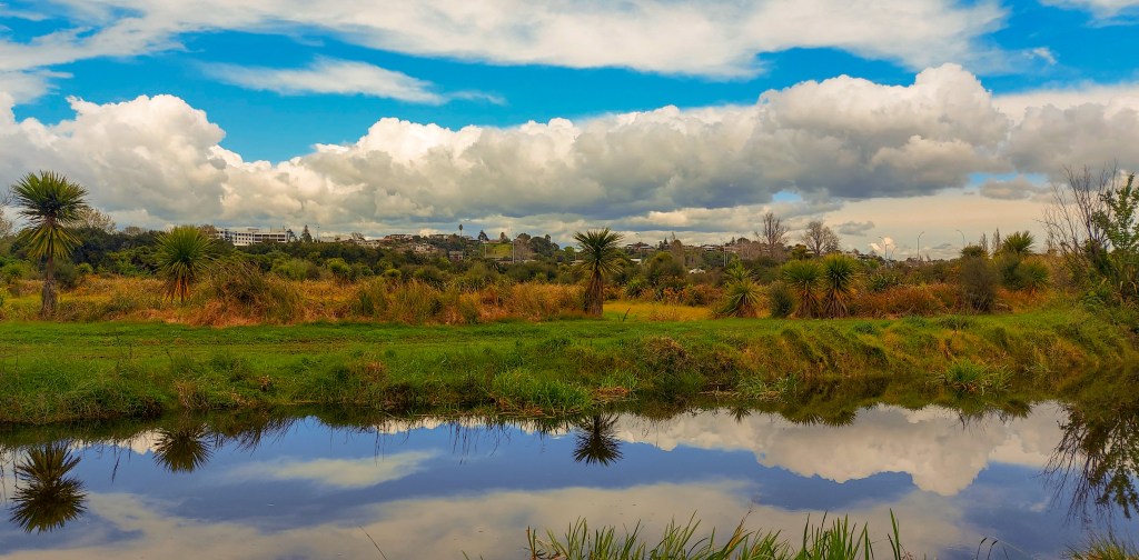
This goes back to the times when the hapū lived on Motuopae Island and along the Te Papa (where we live) and Ōtūmoetai peninsula, extending right back to the Taumata (Pyes Pā) and onto Ōtanewainuku and Pūwhenua, which are the mountains that mark the limits of their rohe.


I would love this place. Beautiful and fascinating. Thank you.
LikeLiked by 1 person
You’re welcome, Martha. It changes with the seasons and more interesting when there’s more wildlife around. Even the odd cow 😀
LikeLiked by 1 person
It’s great that beautiful terrain is pretty much at your doorstep.
LikeLiked by 1 person
It makes me feel like I have left city life behind when enjoying these trails.
LikeLiked by 1 person
How lovely to be so close to such a beautiful area.
LikeLiked by 1 person
We are fortunate that there are nature reserves to walk and cycle without the hassle of traffic. It’s a popular spot for cycling.
LikeLiked by 1 person
The new wetland is looking fantastic, Suzanne. Thank you for the information on this historically significant area.
LikeLiked by 1 person
You are most welcome, Tracy.
LikeLiked by 1 person
It looks a haven of peace, Suzanne. The names don’t easily roll off my stubborn tongue but you seem to have mastered the language well.
LikeLiked by 1 person
Jo, it’s much easier to write it correctly, thanks to Ms Google, than pronounce the Maori language. As much as I try, I can’t pronounce many Maori words with confidence.
LikeLiked by 1 person
What a beautiful trail you walked.
LikeLiked by 1 person
To be honest, Sue, I’ve cycled this area than I’ve walked it. Either way, it’s enjoyable.
LikeLiked by 1 person
Another inviting trail with fascinating history
LikeLiked by 1 person
Beautiful scenery and fascinating background history – looks a great place to walk and take photos 🙂
LikeLiked by 1 person
To be honest, Sarah most times I’m cycling and with others who getting annoyed if I stop too often 😉 When by myself I go for a more leisurely stroll or cycle and take more photos.
LikeLiked by 1 person
I would definitely be sauntering through that beautiful scenery. So lovely that’s it’s close to home.
LikeLiked by 1 person
We are very spoilt with walking and cycling trails around the Bay of Plenty and more so Tauranga.
LikeLiked by 1 person
I’m glad the city is caring for its urban wetlands areas – so important for wildlife.
LikeLiked by 1 person
Wetlands are so very important for ecological survival of many species not to mention for the mental health of humans. I enjoy seeing children out with adults cycling or checking out the environment than seeing them heading to a shopping mall. In my humble opinion a city can’t have enough green spaces.
LikeLiked by 1 person
Looks like a very interesting trail. And nice that it is close to home. A place to record month by month for the changes.
LikeLiked by 1 person
It is a brilliant way to get from one section of the city to another without using the roading system which is usually congested during business hours and beyond. Not sure there is enough change to do a monthly one, that sort of photograhy is best down the line or in the South Island.
LikeLiked by 1 person